

4 October 2007 Edition
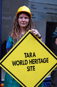
Tara and the Boyne as a World Heritage site or...
The wrong road in the wrong place?
WHY is the controversial M3 road being built where it is, how was the decision taken, who was consulted, who benefits from the road? And now, with the EU investigating the discovery of new archaeological sites along the proposed route at Lismullen, this week An Phoblacht’s ROBBIE SMYTH charts the history of decision making, lobbying and clashing political interests that are adding up to an embarrassing debacle that could ultimately destroy an irreplaceable link to Ireland’s past history - the ancient seat of the High Kings of Ireland - and an untapped tourist resource.
HOW MANY roads have their own personal web site? The controversial M3 does, courtesy of the National Roads Authority. But it is outnumbered by the web sites, blogs and internet postings of groups opposed to a motorway which will cut through not just the ancient Tara and Skryne valley but also through an increasing number of unique archaeological sites, some of which are only newly discovered this year.
Yet the M3 construction will steamroller on, potentially eradicating a unique world heritage site for the short-term expediency of moving 22,000 vehicles quicker to and from work. It is ironic that so much effort is being made to accommodate a transport technology that, with global oil stocks supposedly dwindling, might not survive the 2,000 years or more that the archaeological sites it will cement and tarmac over have lasted so far.
So where did it all begin? The origins of this story are not in Ireland but in Britain and the corridors of anonymous offices in Brussels and the impact of the EU funding dispensed from there has on the Irish economy. In the aftermath of Ireland’s entry, North and South, to the then EEC in 1973, the EU Commission’s attitude to creating a single market was not just about currency and trade laws but also about infrastructure.
To link markets across Europe, roads, rail, ports, airports, telecommunications, energy and even educational institutions would be linked by common standards: a degree in Ireland would be a degree in France or Germany, and a road in Ireland had to be like a road in Europe. And herein lies the first chapters of the M3 story.
Its predecessor, the N3, is a British-built road and mirrors a series of other arteries running from Dublin city centre out into rural Ireland from the M1 to Dundalk round to the N11 which runs south from Dublin to Wexford. Its origins were only partially about access to the capital but also about the exercise of British political power from Dublin Castle to the rest of Ireland.
During the 19th Century, an expansive system of railways, canals, port development and river navigation schemes were built in Ireland, the Shannon navigation system being the centrepiece of this process on water while Dublin was one of the first cities in the world to have an urban rail system.
‘Roads first’
In the years after partition, the most important decision in terms of the current M3 was taken by Fianna Fáil in government. Faced with substantial bus, rail and canal networks that criss-crossed the island, Fianna Fáil decided that they couldn’t countenance either maintaining the existing level of services or investing in new resources, so they let the canal and rail networks fall into decay, closing lines and services while maintaining a bus network that was barely holding its own. Private car transport on-road would be the centrepiece of Irish transport policy.
The different private rail and bus operators were merged in 1946 into CIE, a state-owned bus, rail and canal company. The first train lines were closed in 1959, including the Harcourt Street line (recently reopened for the LUAS). In later years, the train lines from Derry, Monaghan and Navan would be closed also, depriving those regions of a vital transport infrastructure.
The rail line closures had two effects: freight transport moved increasingly to the roads and car ownership rose as rural homes were left without a rail or bus service and had only the car as a means of travel.
Coping with extra road traffic on what was initially an under-used network was managed by a series of town and city bypasses to mixed success, the most notorious failure of this strategy being Dublin’s grid-locked M50.
EU money
When the EU offered to fund road building in Ireland it was under the condition that their favoured motorway system be used. At the time, many so-called ‘national roads’ being built in Ireland were broad highways, with room for overtaking and wide hard shoulders to allow for some driver error and cut down on road accidents.
The EU-funded roads would be much more expensive and environmentally invasive three-lane motorways. In the 1970s and 1980s, the EU co-funded a range of bypasses and national road improvements, but it was in the period 1989 to 1993 that the next major phase in Irish road development began.
The EU Operational Programme on Peripherality coincided with the first of the current phase of 26-County National Development Plans. At the time, the Dublin Government’s National Institute for Physical Planning and Construction Research, An Foras Forbartha, oversaw such projects.
In 1994, it was replaced by the National Roads Authority (NRA) which manages and wholly controls the government’s road-building projects. The NRA makes the plans, invites tenders and allocates government funds. In 1993, this involved an annual spend of €304 million; in 2005, it was €1.3 billion.
The core failure in the EU plan was that in most other EU states, except for Britain, there was substantial and ongoing investment in public transport, particularly rail, so the road-building project was part of an overall public transport policy. In Ireland, it was roads first and last. Renewed rail investment has only recommenced in the last seven years and investment in bus services has been only to maintain the existing level of service provision.
The NRA and the M3
The National Roads Authority (NRA) is one of the best examples of how modern government operates in Ireland. It has a substantial annual budget and spends considerable sums of tax-payers’ money but is only politically accountable in a strategic way. The day-to-day decisions of the NRA are virtually unchallengeable.
It was tasked by the then Fianna Fáil Environment Minister, Padraig Flynn, to build a network of “safe and efficient” roads. It has to build them to budget and as quickly as possible.
The only way of stopping the NRA carrying out a particular action is by ministerial order. The day the NRA was brought into law by a Dáil and Seanad vote was the last day either of these legislatures had any say on how that body operates. Strategic planning of Irish roads happens in the NRA offices, not through any elected body.
For example, in the 2002 to 2007 Dáil, Sinn Fein TD Aengus Ó Snodaigh repeatedly questioned the decision of the NRA, supported by the Fianna Fáil/Progressive Democrat coalition, to have the M50 roll over the site of Carrickmines Castle in South Dublin.
Ó Snodaigh was either ruled out of order by the Ceann Comhairle or told that the matter was before the courts or awaiting a Bord Pleanála adjudication. Even though he was an elected representative, he was powerless to have any influence over the M50 interchange.
In that Dáil, the Green Party TDs were quite vocal on not just the M50/Carrickmines issue but on opposing the proposed M3 motorway too. But now they’re in government. The Green Party leader, Minister John Gormley, has stated in a letter to Marcin Libicki, chairperson of the European Parliament’s Committee on Petitions: “I do not have responsibility for the M3 or its routing.” John Gormley is the Minister for the Environment.
Reading Gormley’s web blogs makes for a fascinating insight into modern government and on how he contacted the Attorney General and found he could do nothing to stop the road. It does not explain, though, why the Greens did not make halting the M3 and the Tara controversy - a key issue in Green thinking, one would have thought - a condition of entering government.
What is the M3?
The M3 was initially mooted as part of the 1994 to 1999 National Development Plan, but was it was in only in 1999 that the NRA started the planning process for the road.
Its economic purpose is to link Dublin with the hub town of Cavan. The road, which will run from Clonee to Carnacross, is 59km long and it is envisaged that it will cost over €800 million to build.
So other than to connect Dublin and Cavan, which are already linked by the N3, why do we need a motorway between the city and Cavan town? It boils down to one simple statistic - 22,000 vehicles will be able to travel on the route more quickly every day.
The NRA claims that the N3 is one of the busiest transport corridors linking rural Ireland to Dublin and it will also allow motorists to bypass Dunshaughlin, Trim, Navan and Kells. They have not accepted that bypasses of these towns could be built without the construction of a motorway. The 26 Counties is filled with these bypasses and most work well.
There is another key failure in the NRA thinking. It is only in the last few years that the NRA’s work has been included in a state-wide transportation policy, Transport 21. Transport 21 is, with a nod to a metro in Dublin and an extended LUAS line, still rooted in a road-based transport strategy. So the issue of linking Cavan by rail to Navan and then on to Dublin is not included in the plan. The M3 has become part of Transport 21 but the original proposal was mooted before Transport 21 ever existed.
The most controversial section of the road runs from Dunshaughlin to Navan. The current proposed route cuts through a valley which holds the Tara ring forts. Next to the nearby Newgrange, Knowth and Dowth passage tombs, this is one of the most well-known symbols of ancient Ireland.
The people protesting about the road cutting through the Tara Skryne valley make a simple argument for moving the road. It is that while the proposed motorway does not cut through the monument and will run 2km away from the Tara site, the road planners have not taken account of Tara in its wider context, which is that the Tara Skryne valley is itself is at present a virtually undisturbed landscape since the time that Tara was the political centre of the island.
The only change to the landscape has been the more intensive farming in the area, which is far less environmentally invasive than a motorway that will include a large roundabout interchange flooding the area with artificial light at night. So a landscape undisturbed for thousands of years is now to become industrialised with not just super-wide roads and embankments but the glow of neon lighting too.
The NRA position
The NRA claims it considered 10 possible routes for the M3 around Tara and that this is the best option. Part of the NRA’s problem is that the area is filled with archaeological sites including a hill fort (Ringlestown Rath, 2.5km from Tara and Skreen hill top). Other routes would affect as yet undocumented archaeological sites.
The NRA claims that it cannot widen the existing N3 as it is lined with occupied houses. It also argues that a lot of new archaeological finds in the area were only made because of the road building in the first place and it would be “practically impossible” to move the line of the road to avoid all archaeology. So far, 160 sites along the route have been identified.
The NRA says that there was extensive consultation and a 28-day oral hearing conducted by An Bord Pleanála and that 4,000 people attended the public consultations.
But of all the reasons used to justify the route chosen by the NRA, archaeological sensitivities came behind other issues such as avoiding house demolition, splitting farms and having the shortest possible route. One route would have involved a major bridge across the Boyne, which the NRA said would have a substantial visual impact on the environment, yet a huge bridge has already been built across the Boyne to facilitate the new M1 toll road.
The World Heritage site option
There is a final option that is it seems not to have considered and that would be not to build that road.
UNESCO (the United Nations Educational, Scientific and Cultural Organisation) currently has three designated World Heritage sites in Ireland: the already-mentioned ones at Newgrange plus the Giant’s Causeway and Skellig Michael, off the coast of Kerry. The Irish Government - including the Green Party - could make the broader Tara Boyne region, including the 1690 Battle of the Boyne area, into a three-piece World Heritage site and invest in it as a tourist resource that rivals the Valley of the Kings or the Grand Canyon in the United States.
A survey conducted by RedC Research found that seven out of ten people polled wanted the M3 to avoid the Tara Skryne valley, so there is support for ending nearly a century of bad decision making on transport and take just one good one - not to build the road.
Tara — Ireland’s historic political and spiritual capital
FROM the time of the first Celtic influence, until the 1169 invasion of Richard de Clare, the Hill of Tara was the island’s political and spiritual capital. It was the coronation place and seat of the High Kings of Ireland.
Tara has significant spiritual significance as well as historical importance. Even before the conversion by St Patrick of Ireland’s High Kings it was a place where the Irish sought to express their spirituality. It was the birthplace of Christianity in Ireland.
During the 1798 Rising, United Irishmen formed a camp on the hill but were attacked and defeated by British troops on 26 May 1798 and the Lia Fáil was moved to mark the graves of the 400 rebels who died on the hill that day. In the 19th Century, Daniel O’Connell MP led a political demonstration on Hill of Tara in favour of repeal of the Act of Union which drew over 750,000 people.
This year, in a letter to the Irish Times on 29 January, Joe Fenwick from the Department of Archaeology at the National University of Ireland in Galway, applauding the Irish Government’s decision to preserve the last HQ of the leaders of the 1916 Easter Rising at 16 Moore Street as a national monument, asked why the same could not be done for Tara.
Another letter writer, in the Irish Independent of 23 April 2007, urged readers:
“The next time you see Bertie Ahern wrapping himself in the flag at Croke Park, think of the fate of Tara, 2,000 years older than the GAA, Fianna Fáil or the GPO.”
The World Monuments Fund has placed Tara on its list of ‘100 Most Endangered Sites’ worldwide.